Λειψυδρία στην Κάρπαθο (Also in English)

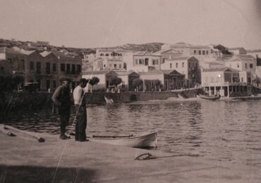
Διαβάζοντας ότι ο Δήμος θα μεταφέρει καθημερινά 300 κυβικά μέτρα αφαλατωμένου νερού για τις υδρευτικές ανάγκες του Απερίου, νόμισα ότι ξύπνησα από ένα παράξενο όνειρο. Η μνήμη μου πήγε πάνω από 80 χρόνια πίσω, όταν μετακομίσαμε στο Απέρι για να αποφύγουμε τους βομβαρδισμούς του Δευτέρου Παγκοσμίου Πολέμου, και αργότερα όταν φοιτούσα στο Γυμνάσιο.
Συχνά, με άλλα παιδιά, πηγαίναμε στην πηγή της Βλύας να παίξουμε νεροπόλεμο με το κρυστάλλινο νερό που έτρεχε ασταμάτητο μέσα από τρεις πετρόκτιστες «χολέτρες» (υδρορροές) και έφτανε μέχρι την Κολυμπήθρα, και σε όλη αυτή την διαδρομή του κινούσε πάνω από 20 νερόμυλους και πότιζε κήπους και αμπέλια με οπωροφόρα δέντρα και λαχανικά.
Εκτός της Βλύας υπήρχε και η πηγή κάτω από τα πλατάνια δίπλα στο μεγάλο γεφύρι, η πηγή στου Κυρκαλού και άλλες πιο μικρές πηγές. Επίσης στους Λώρους υπήρχε μια μικρή υπόγεια πηγή που το νερό της συγκεντρωνόταν σε μια περτόκτιστη γούρνα που την ονόμαζαν Λίμνη. Επίσης, η κοινότητα για να διευκολύνει τους κατοίκους για προμήθεια νερού οικιακής χρήσης, δημιούργησε υδρευτικό δίκτυο με πέντε δημόσιες βρύσες: στους Λώρους κοντά στο σπίτι της Ειρήνης Ματσάκη και δεύτερη κοντά στην εκκλησία του Αγίου Ιωάννη, στον Άγιο Βασίλη, στην Βαλαντού κοντά στην εκκλησία του Χριστού και στο σχολικό προαύλιο.

Οι υδροφόρες πηγές της Καρπάθου επεκτείνονταν σε όλη την Κάρπαθο. Η πηγή της Αρκάσας με ημερήσια ροή 2000 κυβικών μέτρων, μετρημένη επί Αγγλοκρατίας, ήταν η μεγαλύτερη της Καρπάθου, κινούσε 15 νερόμυλους και πότιζε αρκετές δεκάδες αμπέλια που τα λαχανικά τους έφταναν μέχρι την Κάσο. Μια άλλη πηγή υπήρχε μεταξύ Αρκάσης και Μενετών, στους Κάτω Γύρους. Στις Μενετές λίγο πιο κάτω από τον αυτοκινητόδρομο υπήρχε μια υδρευτική πηγή και μια αρδευτική στο Λάι.
Όταν τα Πηγάδια άρχισαν να αναπτύσσονται, η πιο κοντινή πηγή βρισκόταν στα Βρουλίδια, όπου έκτισαν το «Τούρκικο υδραγωγείο» για να αποθηκεύουν το νερό στο διάστημα της νύχτας, και μια δεύτερη πηγή για ύδρευση υπήρχε στο «παράκαιρο» στην Δαματρία. Για το πότισμα των ζώων οι βοσκοί της περιοχής χρησιμοποιούσαν πηγάδια από τα οποία τα Πηγάδια πήραν το όνομα τους. Επίσης, για το πότισμα των ζώων, οι βοσκοί χρησιμοποιούσαν τις πηγές στο Μέρτος και στην Βαργάρα. Στην Γλυφά, κοντά στην θάλασσα, υπήρχε πηγή με υφάλμυρο νερό του το χρησιμοποιούσαν στο κτίσιμο των οικοδομών.
Στο διάστημα της Ιταλοκρατίας κατασκευάσθηκε υδραγωγείο στο οποίο κατέληγε το νερό της πηγής της Μύλης και δημιουργήθηκε υδρευτικό δίκτυο. Τρεις δημόσιες βρύσες υπήρχαν προτού φτάσει το νερό στο υδραγωγείο (στο εκκλησάκι της Κυράς Παναγιάς, κοντά στο μηχανουργείο του Νικολάου Παχούντη και μπροστά στο σπίτι του Νικήτα Ζαβόλα) και άλλες επτά από το υδραγωγείο στο λιμάνι (μπροστά στο σπίτι του Αριστείδη Ματσάκη, δίπλα στου Μελισσιανού το καφενείο, κοντά στου Αλέξη Μανωλάκη το μαγαζί, δίπλα στου Μιχάλη Μακρή το μαγαζί, μπροστά στο σπίτι της Σοφία του Λάμπρου στο Ρυάκι, μπροστά στο σπίτι του Νίκου Σταματάκη και μπροστά στο σπίτι του Γιανναγά στο λιμάνι), συνολικά δέκα βρύσες. Το ίδιο δίκτυο εξυπηρετούσε το Διοικητήριο και την Αστυνομία.

Σε όλα τα άλλα χωριά υπήρχαν πηγές με τρεχούμενο νερό μέσα στο χωριό και στα μετόχια για ύδρευση και άρδευση. Στην Βωλάδα υπήρχαν πηγές στο Πίνι και στο οροπέδιο της Λάστου, στην Ταυτούα στο Πάνω Κούρι και στον Άη Γιάννη στο Κάτω Κούρι. Στο Όθος η κεντρική πηγή ανέβλυζε μέσα στο χωριό κάτω από την εκκλησία της Παναγίας, υπήρχαν και άλλες πηγές στις Στες, στον Έλοθα και στον Άη Γιώργη στις Βάσσες. Στις Πυλές η κεντρική πηγή μέσα στο χωριό ανέβλυζε κάτω από την εκκλησία του Σταυρού και στο Ακρωτήρι έρεε ασταμάτητη μια από τις μεγαλύτερες πηγές της Καρπάθου, ημερήσιας ροής 600 κυβικών μέτρων, μετρημένη επί Αγγλοκρατίας. Από αυτή την πηγή, ο Βασίλης Λυριστής πότιζε ένα μεγάλο αμπέλι με οπωροφόρα δέντρα και λαχανικά και κινούσε και ένα νερόμυλο. Σχεδόν όλο το νερό κατέληγε στην θάλασσα. Λίγο πιο πέρα από το Ακρωτήρι υπήρχε μια μικρή πηγή με θεραπευτικές ιδιότητες.
Ξεκινώντας από το Απέρι προς την κεντρική Κάρπαθο συναντούσες μια μικρή πηγή στο Σταυρί και μια πιο μεγάλη στο Κατώδιο που πότιζε τα αμπέλια της περιοχής. Στο Μερτώνα υπήρχε μια μεγάλη πηγή κάτω από τα πλατάνια που έτρεχε μέσα από πετρόκτιστες χολέτρες, είχε τόσο πολύ νερό που κινούσε νερόμυλους. Στο Μερτώνα υπήρχαν και άλλες δυο πιο μικρές πηγές, η μια κοντά στο εκκλησάκι της Πάνω Παναγιάς και άλλη στον Πέρα Μερτώνα. Με αυτές τις τρεις πηγές ποτίζονταν όλα τα αμπέλια μέσα στην κοιλάδα που κατέβαινε προς την θάλασσα.
Δεξιά του κεντρικού δρόμου των Σπόων βρίσκεται η κεντρική πηγή που εξυπηρετούσε τις υδρευτικές ανάγκες των κατοίκων του χωριού και πότιζε και μερικά αμπέλια που βρίσκονταν στην ίδια περιοχή. Άλλη πηγή υπήρχε στον Άγιο Νικόλα και σε άλλα μετόχια των Σπόων, όπως στις τοποθεσίες: Καλαμάγρα, Κυρτός, Αφή Σκαλί και Καλαμιώνας.

Φθάνοντας στο Μεσοχώρι ο επισκέπτης εντυπωσιάζεται από την Πηγή της Βρυσιανής που τρέχει μέσα από τρεις μαρμάρινες χολέτρες κάτω από την εκκλησία και απαθανάτισε η Ευδοξία Λύκου-Διάκου: «Ποιος έχει τέτοια Παναγιά, να βγάζει απ’ τα θεμέλια/ νερό, να πίνει το χωριό, και να ποτίζει αμπέλια». Στο Μεσοχώρι υπήρχε και η πηγή του Πικάπου, που είχε τόση μεγάλη ροή που κινούσε νερόμυλους. Οι δυο αυτές πηγές με την πηγή του Μαστρομηνά πότιζαν τα αμπέλια με οπωροφόρα και λαχανικά που άρχιζαν πάνω από το χωριό κατεβαίνοντας προς την θάλασσα.
Η Όλυμπος, το μεγαλύτερο σε έκταση και πληθυσμό χωριό της Καρπάθου, διέθετε τις περισσότερες πηγές. Αρκετές απ’ αυτές έρεαν από τις πλαγιές του Προφήτη Ηλία όπου ήταν κτισμένη η Όλυμπος. Μια απ’ αυτές, η Μέσα Βρύση, βρισκόταν πολύ κοντά στον οικισμό και τη χρησιμοποιούσαν για ύδρευση, ενώ οι άλλες (Βρυσούλλι του Χριστού, Φραγκούλλη, Φλέα, Πραστίος, Γυντζουράς, Κάτω Βλύστης, Κλήματος, Αποσκίνου, Αλάπατος, Κάτω Βρύση, Λευκαντείος, Κοριακόνι, του Χαρκιά το πηάι) βρίσκονταν έξω από το χωριό. Από τον ορεινό όγκο Κορύφι προέρχονταν και οι πηγές Αλεμονήτρια, Βαθύς Ποταμός, Καμαράκι, το Καλοκαιρινό Νερό, που βρίσκονταν και αυτές κοντά στο χωριό. Από το νερό που έτρεχε στον ποταμό της Ολύμπου, κυρίως από τις πηγές της Μέσα Βρύσης, του Φραγκούλλη και της Φλέας, κινούνταν δεκατρείς νερόμυλοι.
Μεταξύ των άλλων, στην ευρύτερη περιοχή της Ολύμπου υπήρχαν οι πηγές Καλάμια, Άγγελος, Μεσιακές, Απόλλωνα, Πυλάι, Καλαμώνας, Νερόμυλος τ’ Ασπρούλλη, Σεσεμές, Επικαρίοι, Λέκκυφος καθώς και η πηγή της Βανάντας, λίγο βορειότερα από το Διαφάνι. Στα νότια της Ολύμπου, στην ευρύτερη περιοχή του Αγρέλλη, υπήρχαν πολλές διάσπαρτες πηγές μέσα στα πευκοδάση, όπου μπορούσε κανείς να συναντήσει και τον ενδημικό βάτραχο της Καρπάθου, Οι διαμένοντες στον γεωργικό συνοικισμό της Αυλώνας, που δεν υπήρχε πηγή, υδρεύονταν από «λατσίες», δεξαμενές που συγκέντρωναν το βρόχινο νερό.

Εκτός από τις ονομαζόμενες πηγές υπήρχαν αρκετές δεκάδες άλλες σε όλη την Κάρπαθο, που ένας περιηγητής επηρεαζόμενος απ’ αυτές έγραψε το «Κάρπαθος με τα κρύα νερά …». Τώρα προβάλλει το ερώτημα, τι συνέβη και σε λιγότερο από ένα αιώνα, οι πιο πολλές πηγές στέρεψαν και αυτές που έμειναν λιγόστεψε η ροή τους. Απάντηση: η πυρκαγιές και αποψίλωση των δασών, η σχεδόν πλήρης εγκατάλειψη της γεωργίας και η κλιματική αλλαγή.
Πριν από ένα αιώνα το 50% της Καρπάθου καλυπτόταν από πευκοδάση και δάση χαμηλής βλάστησης. Η προφορική παράδοση αναφέρει ότι το πευκοδάσος στον Αγρέλλη της Ολύμπου ήταν τόσο πυκνό που από μέσα του δεν μπορούσε να περάσει ούτε φίδι. Τα δάση καθυστερούσαν την ροή του νερού προς την θάλασσα και βοηθούσαν στην απορρόφησή του από το έδαφος. Το ίδιο και οι αγροί στα πεδινά και στις πλαγιές των βουνών και των λόφων που στηρίζονταν με ξερολιθιές και καλλιεργούνταν.
Οι Ιταλοί, στο διάστημα της Ιταλοκρατίας, φρόντισαν για την προστασία των δασών. Κατά διαστήματα έκοβαν τα δέντρα που φύτρωναν μέσα στα ρυάκια και σε περίπτωση που έπιανε πυρκαγιά σε ένα μέρος του δάσους η φωτιά δεν μεταδιδόταν στο διπλανό. Επέτρεπαν στους ξυλοκόπους να ξυλεύουν τους θάμνους που φύτρωναν μεταξύ των πεύκων, σε περίπτωση πυρκαγιάς η φωτιά προχωρούσε πιο γρήγορα χωρίς να καίγονται τα πεύκα.

Επίσης κατασκεύασαν δύο δασοφυλάκια για να μένουν οι δασοφύλακες. Πάνω από τον Μερτώνα στο Λυ, μέσα στο δάσος πάνω σ’ ένα πλάτωμα έφτιαξαν ένα ευρύχωρο πέτρινο δασοφυλάκιο μαστορεμένο με περίσσια τέχνη, η σκεπή του ήταν με κεραμίδια γαλλικού τύπου. Από μια δίφυλλη πόρτα πλαισιωμένη από δυο παράθυρα έμπαινες στο δασοφυλάκιο που ήταν πλημμυρισμένο στο φως, καθώς και στους πλαϊνούς τοίχους υπήρχαν μεγάλα παράθυρα. Το άλλο ήταν ξύλινο και βρισκόταν στην δυτική Κάρπαθο, στις Μεσάθες στην περιοχή του Μεσοχωρίου. Όταν ένα δάσος έπιανε φωτιά επιστρατεύονταν όλοι οι άνδρες των γειτονικών χωριών, από 18 μέχρι 60 ετών, για να την σβήσουν.
Οι βροχοπτώσεις στην Κάρπαθο επηρεάζονται από την υποτροπική ζώνη υψηλής πίεσης (subtropical high-pressure zone) που βρίσκεται στην έρημο της Σαχάρας, γύρω από τον τροπικό του Καρκίνου (23,5ο βόρεια του Ισημερινού) και εμποδίζει τους ανέμους που πνέουν από τον Ατλαντικό που φέρνουν υγρασία και προκαλούν βροχοπτώσεις. Στην αρχή της άνοιξης, η ζώνη υψηλής πίεσης ανεβαίνει βόρεια και το φθινόπωρο αρχίζει να κατεβαίνει νότια. Γι’ αυτό, στην Κάρπαθο οι βροχές αρχίζουν το φθινόπωρο, δυναμώνουν τον χειμώνα, λιγοστεύουν την άνοιξη και σταματούν το καλοκαίρι. Η κλιματική αλλαγή προκαλεί την ελάττωση των βροχοπτώσεων στην Κάρπαθο.
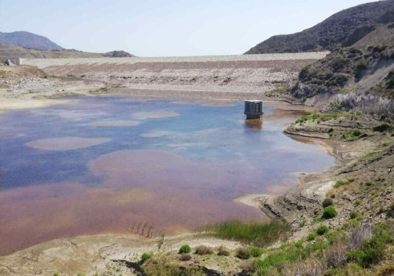
Από την αρχή της δεκαετίας του 1970 ο Δήμος προσπάθησε να λύσει το πρόβλημα με γεωτρήσεις που όμως αντλούσαν από το υπέδαφος περισσότερο νερό από όσο ανανεωνόταν την εποχή των βροχών, που το πιο πολύ πήγαινε στη θάλασσα λόγω της αποψίλωσης των δασών. Το νερό λιγόστευε, οι γεωτρήσεις πήγαιναν όλο και πιο βαθιά, μέχρι που οι αντλήσεις περιορίστηκαν ή σταμάτησαν. Η επόμενη λύση ήταν το φράγμα Σχοινά, πέρασαν πάνω από δυο δεκαετίες χωρίς εφικτό αποτέλεσμα.

Τώρα φτάσαμε και βρισκόμαστε στην αφαλάτωση που γίνεται με την τεχνική της ηλεκτρόλυσης, της αντίστροφης ώσμωσης και με άλλες τεχνολογίες που παράγουν υψηλής ποιότητας νερό σε μεγάλες ποσότητες. Τέτοιες εγκαταστάσεις άρχισαν να δημιουργούνται και στην Κάρπαθο.
Water scarcity in Karpathos
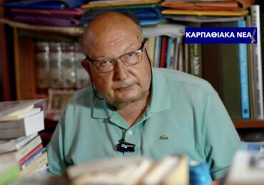
By Manolis Cassotis
Reading that the Municipality of Karpathos will transport 300 cubic meters of desalinated water daily for the water needs of Aperi, I thought I woke up from a strange dream. My memory went back over 80 years, to when we moved to Aperi to avoid the bombings of World War II, and later when I was in high school.
Often, with other children, we would go to the spring of Vlya to play water fights with the crystal-clear water that flowed unstoppably through three stone-built “choletras” (watercourses) and reached Kolymbithra, and along its entire route it powered over 20 watermills and irrigated gardens and fields with fruit trees and vegetables.

Apart from Vlya, there was also the spring under the plane trees next to the big bridge, the spring at Kyrkalos and other smaller springs. Also, in Loroi was a small underground spring whose water was collected in a stone cavity called “Limni” (Lake). The community, to facilitate the residents’ supply of water for domestic use, created water supply network with five public taps: in Loroi near the house of Irini Matsakis and a second one near the church of Saint John, in Saint Basil, in Valantou near the church of Jesus Christ and in the school yard.
The water sources of Karpathos extended throughout the island. Arkasa’s spring with a daily flow of 2000 cubic meters, measured during the British administration, was the largest in Karpathos, powered 15 watermills and irrigated several dozen fields whose vegetables reached as far as Kasos. Another spring existed between Arkasa and Menetes, in Kato (Lower) Gyroi. In Menetes, just below the highway, there was a water source and an irrigation spring in Lai.
When Pigadia began to develop, the nearest spring was in Vroulidia, where they built the “Turkish aqueduct” to store water during the night, and a second spring for water was in the “parakeiro” in Damatria. For watering the animals, the shepherds of the area used wells from which Pigadia (Well) took its name. Also, for watering the animals, the shepherds used the springs in Mertos and Vargara. In Glyfa, near the sea, there was a spring with brackish water that they used in the construction of buildings.

During the Italian occupation, an aqueduct was constructed to which the water of the Myli spring ended, and water supply network was created. Three public taps existed before the water reached the aqueduct (at the chapel of Kyra Panagia, near the machine shop of Nicholas Pahountis and in front of Nikitas Zavolas’ house) and another seven from the aqueduct to the port (in front of Aristides Matsakis’ house, next to the cafe of Melissianos, near the shop of Alexis Manolakis, next to the shop of Michael Makris, in front of the house of Sophia Lambros in Ryaki, in front of the house of Nick Stamatakis and in front of Doctor Giannagas’ house at the port), a total of ten taps. The same network served the Administration and the Police buildings.
In all the other villages there were springs with running water within the village and in the metochia (field communities) for water supply and irrigation. In Volada there were springs in Pini and on the Lastos plateau, in Taftua in Upper Kouri and next to Saint John chapel in Lower Kouri. In Othos the central spring gushed within the village under the church of Panagia, there were other springs in Stes, in Elothas and in Saint George in Vasses. In Pyles the central spring within the village gushed beneath the church of Holy Cross and in Akrotiri one of the largest springs of Karpathos flowed unceasingly, with a daily flow of 600 cubic meters, measured during the British administration. Vasilis Lyristis uses this spring to water a large field with fruit trees and vegetables and to power a watermill. Almost all the water ended up in the sea. A little further from Akrotiri there was a small spring with healing properties.
Starting from Aperi towards central Karpathos, you would come across a small spring in Stavri and a larger one in Katodio that watered all the fields of the area. In Mertona, there was a large spring under the plane trees that flowed through stone-built cisterns, it had so much water that it powered watermills. In Mertona, there were two other smaller springs, one near the chapel of Pano (Upper) Panagia and another in Pera (far out) Mertona. With these three springs, all the fields in the valley that descended towards the sea were watered.

To the right of the main road in Spoa is the central spring that served the water needs of the village residents and watered some vineyards located in the same area. Another spring existed in Saint Nicholas and in other districts of Spoa, such as in Kalamagra, Kyrtos, Afi Skali and Kalamionas.
Arriving in Mesochori, the visitor is impressed by the Spring of Vrysiani, which flows through three marble cisterns under the church and was immortalized by Eudoxia Lykou-Diakou: “Who has such a Virgin Mary, who draws water from the foundations, drinks the village, and waters the fields.” In Mesochori, there was also the spring of Pikapou, which had such a large flow that powered watermills. These two springs, together with the spring of Mastromina, watered the fields with fruit trees and vegetables that began above the village and descended towards the sea.
Olympos, the largest village of Karpathos in terms of area and population, had the most springs. Several of them flowed from the slopes of Prophet Elias where Olympos was built. One of them, Mesa Vrysi, was very close to the settlement and was used for water supply, while the others (Christ’s Vrysoulli, Frangouli, Flea, Prastios, Gyntzouras, Kato (Lower) Vlystis, Klimatos, Aposkinou, Alapatos, Kato (Lower) Vrysi, Lefkandeios, Koriakoni, Charkias’s to piai (well)) were located outside the village. From the Koryfi mountain range came the springs Alemonitria, Vathys Potamos (deep river), Kamaraki, to Kalokairino Nero (summer water), which were also located near the village. Thirteen watermills were powered by the water flowing in the Olympus River, mainly from the springs of Mesa Vrysi, Frangoulis and Flea.

Among others, in the wider area of Olympus there were the springs of Kalamia, Angelos, Messiakes, Apollona, Pylai, Kalamonas, Watermill of Asprouli, Sesemes, Epikarioi, Lekkyfos as well as the spring of Vananda, a little north of Diafani. To the south of Olympus, in the wider area of Agrellis, there were many scattered springs in the pine forests, where one could also encounter the endemic frog of Karpathos. The residents of the agricultural settlement of Avlona, where there was no spring, were watered from “latsias” (cisterns) that collected rainwater.
In addition to the named springs, there were several dozen others throughout Karpathos, which a traveler influenced by them wrote “Karpathos with its cold waters…”. Now the question arises, what happened and in less than a century, most of the springs dried up and those that remained had their flow reduced. Answer: fires and deforestation, the almost complete abandonment of agriculture and climate change.
A century ago, 50% of Karpathos were covered by pine forests and low-growing forests. Oral tradition states that the pine forest in Agrellis of Olympus was so dense that not even a snake could pass through it. The forests delayed the flow of water towards the sea and helped in its absorption by the soil. The same was true of the fields in the lowlands and on the slopes of the mountains and hills that were supported by stone walls and were cultivated.

The Italians, during the Italian occupation, took care of the protection of the forests. At intervals, they cut down the trees that grew in the streams and in case a fire broke out in one part of the forest, the fire did not spread to the next. They allowed the woodcutters to cut down the bushes that grew between the pine trees; in case of a fire, the fire would spread more quickly without burning the pine trees.
They also built two forest stations for the rangers to live in. Above Mertona in Ly, in the forest on a plateau, they built a spacious stone forest station crafted with excessive skill, its roof was with French-style tiles. Through a double door framed by two windows you entered the forest station that was flooded with light, and there were also large windows on the side walls. The other forest station was wooden and located in western Karpathos, in Mesathes in Mesochori’s area. When a forest caught fire, all the men of the neighboring villages, from 18 to 60 years old, were recruited to put it out.
Rainfall in Karpathos is influenced by the subtropical high-pressure zone located in the Sahara Desert, around the Tropic of Cancer (23.5° north of the Equator) and blocks the winds blowing from the Atlantic that bring moisture and cause rainfall. At the beginning of spring, the high-pressure zone rises northward and in autumn it begins to descend southward. Therefore, in Karpathos the rain begins in autumn, intensifies in winter, decreases in spring and stops in summer. Climate change decreases the rainfall in Karpathos.

Since the beginning of the 1970s, the Municipality tried to solve the problem with boreholes, but they pumped more water from the ground than was renewed during the rainy season, most of which went to the sea due to deforestation. The water was getting scarcer, the boreholes went deeper, until the pumping was limited or stopped. The next solution was the Schina dam, more than two decades passed without any feasible result.
Now we have arrived at desalination, which is done using the technique of electrolysis, reverse osmosis and other technologies that produce high-quality water in large quantities. Such facilities have also begun to be created in Karpathos.